Monday, July 21. 2008
OpenStreetMap Tipp: Auszug von einzelnen Orten (Murrhardt zum Download)
Tuesday, July 8. 2008
RFID Zapper
 Unter fachmännischer Anleitung durfte ich mir heute einen eigenen RFID Zapper basteln.
Video vom 22C3 (RFID-Zapper-Teil startet ab 19:00)
Sunday, July 6. 2008
ACID3 with webkit-gtk and midori
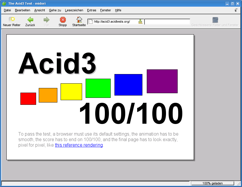 Seems with the latest versions of webkit-gtk and midori, a long-standing crasher-bug got fixed and it now allows you to run the browser-test ACID3.
I just bumped the webkit-gtk ebuild in Gentoo to the latest snapshot.
ACID3 is a test for the standards compliance of modern web browsers. I wrote about ACID2 some years ago.
Saturday, July 5. 2008
GPN7 and surveillance cameras in OpenStreetMap
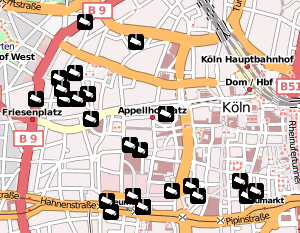 It's the second day on the GPN7 (a local hacker event from the Chaos Computer Club Karlsruhe / Entropia).
Yesterday evening I hacked together a map based on openstreetmap showing surveillance cameras:
http://osm-cctv.hboeck.de/
As a basis, we could use some data provided by the chaos computer club cologne. I'm working on an importer to get that into the openstreetmap database. Will probably happen within the next days.
All cameras tagged with man_made=surveillance in germany.osm are already imported into the overlay. I'll keep a wiki-page up-to-date at:
http://wiki.openstreetmap.org/index.php/User:Hanno/CCTV
Wednesday, July 2. 2008
Routable OSM maps on Garmin with MapSource / WINE
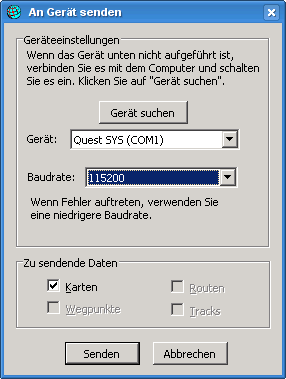 There are two tools out there for Linux to put Garmin maps (which you can convert from OpenStreetMap Data) on devices, sendmap (proprietary) and qlandkarte (free). Sadly, both don't support my device (Garmin Quest), so I had to find an alternative solution. This should also work with other garmin devices.
After some playing around, I managed to get it running with MapSource on wine. I've used wine 1.1.0 on Gentoo, if you have problems, be sure to get a recent wine version.
Steps to do:
- Download MapSource_6137.exe from the Garmin webpage.
- Use 7-Zip to unpack the exe to some directory: 7z x MapSource_6137.exe
- Install MAIN.msi: wine start MAIN.msi
- Install MapSource: wine Setup.exe
- Get one of the MapSource Installers from here and install it: wine Setup_OSM-Germany-2008-06-11.exe
- wine doesn't support usb, so you need the garmin_gps module. If it's installed on your system, it should load automatically after attaching your device and switching it on.
- You should now have a device ttyUSB0, which you need to symlink as com1 for wine: ln -s /dev/ttyUSB0 ~/.wine/dosdevices/com1
- Run MapSource: wine ~/.wine/drive_c/MapSource/MapSource.exe
- Go to Settings -> Transfer, there you can select a serial port. Select COM1.
- Click the map selection tool from the buttons and select an area.
- Select Transfer -> Transfer to device. If everything went fine, it'll detect your garmin device attached to the serial port and you can start your upload.