Entries tagged as josm
english babelfish cacert camera canon china chinese cryptography csrf email etymologie gadgets gammu gentoo gnokii googletranslate gphoto journalist language linux mandarin media merkaartor mobile moodle nokia openssl openstreetmap ptp rc2 russia russian s9y security serendipity smime ssl time translation travel universaltranslator websecurity writing xss gebabbel gps gpsbabel mobiletrailexplorer 3d ac100 addresssanitizer aiglx android asan beryl bufferoverflow c censorship clang compiz compizfusion composite developer france freedomofspeech freesoftware gcc idn iputils kde laptop lenovo libressl memorysafety metacity nancy notebook openbsd php ping politics rmll smartbook subnotebook thinkpad tls toshiba ubuntu useafterfree x1carbon xgl xorg zensur entropia exif freeculture garmin geo geocaching geodaten geotagging google gpx hardware jpeg karlsruhe mapsource murrhardt quest routing wine backnang badcannstatt cannstatt film freifunk kino osm osm2poly osmosis press rtl wlan augsburg augsburgerallgemeine berlin bnn bonn c4 ccc cccs cctv chemnitz datenschutz earth froscon froscon2007 gpn gpn7 kaisersbach ludwigsburg lug luga lugbk mars messe openexpo opensourceexpo peterschaar planet presse privacy re-publica re-publica09 rp09 schokokeks sfd siegburg softwarefreedomday spiegel stuttgart surveillance talk tomorrow überwachung überwachungskameras video web20 webinale zeitung
Monday, July 21. 2008
OpenStreetMap Tipp: Auszug von einzelnen Orten (Murrhardt zum Download)
Friday, February 29. 2008
merkaartor, another editor for OpenStreetMap
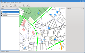 After some more »out of memory«-messages by josm, I thought it's time to look out for alternatives.
For the openstreetmap-project, the two main editors are josm (java) and potlach (flash). I think using java probably wasn't a very wise decision (I still wonder how an app can get »out of memory« after loading about 5 MB of images, do they create a pixel class and store every pixel in an object?) and I don't like flash either.
There's another project called merkaartor and today I had a look. My first feeling is that it's promising. It has good performance, it does nice live-rendering and it supports the basic features (adding nodes and ways, up/downloading stuff to the osm-system).
Sure, comparing to the large list of plugin features josm has, it's limited. Maybe I'll try to hack in some bits I'm missing at the moment.
In my continuing effort to improve gentoo for geo-related stuff, I've just added a merkaartor package to portage.
Saturday, September 8. 2007
Make Gentoo OSM-ready
Quicksearch
About me
You can find my web page with links to my work as a journalist at https://hboeck.de/.
You may also find my newsletter about climate change and decarbonization technologies interesting.
Hanno Böck
mail: hanno@hboeck.de
Hanno on Mastodon
Impressum

You may also find my newsletter about climate change and decarbonization technologies interesting.
Hanno Böck
mail: hanno@hboeck.de
Hanno on Mastodon
Impressum
Creative Commons
![]()
Unless noted otherwise, all content is CC Zero / public domain
