Entries tagged as gps
entropia 4k aiglx assembler c4 ccc cctv datenschutz freeculture geo gpn gpn5 gpn6 gpn7 hacker karlsruhe linux openstreetmap privacy programmieren programming querfunk radio surveillance überwachung überwachungskameras wahl wahlcomputer wahlmaschinen xgl exif geotagging gpx jpeg aavepyörä art berlin br breakcore bücher bundestagunited cedric copyright corruptibles creativecommons culture developingworld dvd elephantsdream film freemusic freesoftware freiheitstattangst fruechtedeszorns goa graffiti gutenberg illegalart iromance jamendo lug movie musik nerosdaysatdisneyland ogg publicdomain remix sony tuxmas tuxmas07 vlc vorbis vorratsdatenspeicherung garmin geocaching geodaten hardware mapsource quest routing wine gebabbel gentoo gpsbabel josm mobiletrailexplorer 3d ac100 addresssanitizer android asan beryl bufferoverflow c censorship clang compiz compizfusion composite cryptography developer english france freedomofspeech gcc idn iputils kde laptop lenovo libressl memorysafety merkaartor metacity nancy notebook openbsd openssl php ping politics rmll security smartbook ssl subnotebook thinkpad tls toshiba ubuntu useafterfree x1carbon xorg zensur abmahnung google bypass gaia geographie googleearth googlemaps javascript murrhardt password passwordalert reverseengineering vulnerability 1und1 atm benchmark bios cardreader cd debian display dmidecode driver dsl energiesparen fma86t freifunk graphics harddisk hddtemp lm_sensors lspci lsusb memorystick mod modding motherboard nouveau ntbba nvidia opengl optiarc p30 p35 pciids pcmcia performance r300 radeon ricoh router samsung sata sd sdricohcs ssd strom support t61 usbids webradio wlan osm osm2poly osmosis agenda21 apache barcamp blog bnn bodensee bundesverfassungsgericht cacert co2 computerspiele datensparsamkeit demonstration ejc enbw energie fricard gamer games informationdisclosure jonglieren killerspiele klimaschutz kohlekraftwerk kubik mysql openexpo opensourceexpo planet press presse rfid rhein simplesharingextensions stadtmitte steinkohle umweltschutz uni vortrag web20 webmontag zkm backnang badcannstatt cannstatt kino rtl augsburg augsburgerallgemeine bonn cccs chemnitz earth froscon froscon2007 kaisersbach ludwigsburg luga lugbk mars media messe peterschaar re-publica re-publica09 rp09 schokokeks sfd siegburg softwarefreedomday spiegel stuttgart talk tomorrow video webinale zeitung ccwn come2linux essen faithfighter flash gnash inkscape molleindustria religion religionskritik swfdec waiblingen
Wednesday, July 2. 2008
Routable OSM maps on Garmin with MapSource / WINE
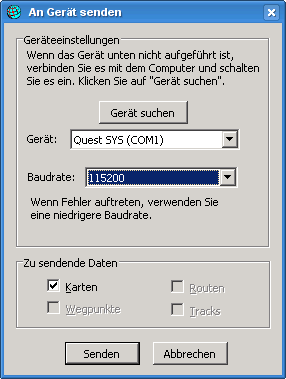 There are two tools out there for Linux to put Garmin maps (which you can convert from OpenStreetMap Data) on devices, sendmap (proprietary) and qlandkarte (free). Sadly, both don't support my device (Garmin Quest), so I had to find an alternative solution. This should also work with other garmin devices.
After some playing around, I managed to get it running with MapSource on wine. I've used wine 1.1.0 on Gentoo, if you have problems, be sure to get a recent wine version.
Steps to do:
- Download MapSource_6137.exe from the Garmin webpage.
- Use 7-Zip to unpack the exe to some directory: 7z x MapSource_6137.exe
- Install MAIN.msi: wine start MAIN.msi
- Install MapSource: wine Setup.exe
- Get one of the MapSource Installers from here and install it: wine Setup_OSM-Germany-2008-06-11.exe
- wine doesn't support usb, so you need the garmin_gps module. If it's installed on your system, it should load automatically after attaching your device and switching it on.
- You should now have a device ttyUSB0, which you need to symlink as com1 for wine: ln -s /dev/ttyUSB0 ~/.wine/dosdevices/com1
- Run MapSource: wine ~/.wine/drive_c/MapSource/MapSource.exe
- Go to Settings -> Transfer, there you can select a serial port. Select COM1.
- Click the map selection tool from the buttons and select an area.
- Select Transfer -> Transfer to device. If everything went fine, it'll detect your garmin device attached to the serial port and you can start your upload.
Monday, February 18. 2008
OpenStreetMap-Talk in Karlsruhe
Monday, February 4. 2008
Geotagging Images
Saturday, September 8. 2007
Make Gentoo OSM-ready
Friday, March 2. 2007
More OpenStreetMapping
Wednesday, February 21. 2007
Die ersten Spuren meiner Tätigkeit in OpenStreetMap
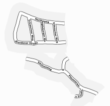 ... dürfen hier bewundert werden.
Erreicht werden kann das im Moment nicht über's normale Interface, sondern nur, wenn man hier rechts oben auf »osmarender« stellt.
Saturday, February 10. 2007
OpenStreetMapping!
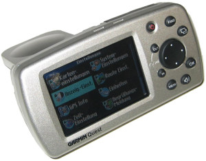 Heute kam mein kürzlich günstig auf ebay erstandener Garmin Quest mit der Post an. Nachdem er mich bereits zuverlässig zum LUG-Treffen navigierte, versuche ich gerade, mich mit diverser Software (josm, gpsbabel) vertraut zu machen.
Nebst der Bekämpfung meiner notorischen Orientierungsschwäche und dem sicherlich gelegentlich folgenden Einsatz zum Geocaching plane ich, tatkräftig das Projekt OpenStreetMap zu unterstützen. Worum es geht? Analog zur Idee freier Software und freier Inhalte sollen frei verfügbare Kartendaten entstehen.
Angesichts der Probleme, die jüngst ein Entwickler eines freien Google Earth-Frontends bekam und der immer wieder auftauchenden Abmahnwellen gegen private Webseitenbetreiber, die Kartenausschnitte als Wegbeschreibung publizieren, ein sicherlich lohnenswertes Unterfangen. Dabei kann ich gleich ankündigen, dass es am 29.3./1.4. eine Mapping Party in Karlsruhe geben soll. Man trifft sich zum Erfassen noch fehlender Gebiete (übrigens gehört Karlsruhe momentan zu den wenigen recht gut erfassten Städten).
Quicksearch
About me
You can find my web page with links to my work as a journalist at https://hboeck.de/.
You may also find my newsletter about climate change and decarbonization technologies interesting.
Hanno Böck
mail: hanno@hboeck.de
Hanno on Mastodon
Impressum

You may also find my newsletter about climate change and decarbonization technologies interesting.
Hanno Böck
mail: hanno@hboeck.de
Hanno on Mastodon
Impressum
Creative Commons
![]()
Unless noted otherwise, all content is CC Zero / public domain
